events
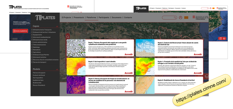
[Video available!] Severo Ochoa Coffee Talk at CIMNE - "πPLATES. Pilot Platform to support Predictive Land Management and Sustainability", by Pere-Andreu Ubach
Wednesday, June 23rd, 2021. Time: 15h
Online - Session link: https://meet.google.com/wgr-kyjv-cyr
ABSTRACT
πPLATES is an ongoing project within the framework of the TDA (Programa de tecnologies digitals avançades de la Generalitat) aimed to develop a tool to diagnose and predict the vulnerability of the territory in anticipation of gradual and disruptive change factors. This solution is based on an augmented Geographical Management System (GMS/GIS++) in which all aspects of the human and the natural world may be recorded, and managed according to several computational models that deepen the understanding and prediction capabilities about the human and natural world. Examples of such models include: advanced diagnostics and forecasts on shoreline erosion, land uses and risk assessment, the relationship between traffic restrictions and improvement in air quality, control of the human presence in natural protected areas to defend biodiversity, or how, when and which industrial areas should be promoted to ensure their sustainability or demoted to avoid waste of resources.
SPEAKER CV
- Civil Engineer with strong focus on Management and Computer Science.
- PhD in Structural Analysis by the Technical University of Catalonia.
- Extense experience in management of Civil Works for very diverse administrations.
- Current Ubach's research activities are centered in Computational Mechanics. The applications are manyfold, but the main ones can be identified in the areas of Aeronautics and Naval Engineering.
- Specialties: Finite Element Method, Construction Management, Research Project Management.
Related items
-
14/11/2024ABSTRACT The Destination Earth Initiative (DestinE) has completed the first phase and the platform ...
-
18/04/2024ABSTRACT This pre-award unit’s event explored key aspects of efficiency and value in AI-drive...
-
17/04/2024ABSTRACT In this work, we propose a convex, finite-dimensional and exact relaxation for non-convex,...
-
19/02/2024ABSTRACT Additive manufacturing techniques, among which 3D Concrete Printing (3DCP) and polymer ext...
-
21/12/2023ABSTRACT This talk is to introduce to the attentive spectator of CIMNE the evaluation process carri...
-
22/11/2023Wednesday, December 13th, 2023. Time: 15h Hybrid! O.C. Zienkiewicz Room, C1 Building, UPC...
-
22/11/2023ABSTRACT One of the main problems one can encounter when modelling wave propagation in saturated an...
-
20/11/2023ABSTRACT Recently, in Italy, many catastrophic events have involved bridges and viaducts in transpo...
-
04/10/2023Wednesday, October 25th, 2023. Time: 12.30 p.m. Hybrid! O.C. Zienkiewicz Room, C1 Buildin...
-
30/09/2023Wednesday, November 29th, 2023. Time: 15h Hybrid! O.C. Zienkiewicz Room, C1 Building, UPC...
-
30/09/2023Wednesday, November 8th, 2023. Time: 15h Hybrid! O.C. Zienkiewicz Room, C1 Building, UPC ...
-
05/05/2023Friday, May 26th, 2023. Time: 12 noon Hybrid! O.C. Zienkiewicz Room, C1 Building, UPC Cam...
-
24/02/2023Wednesday, May 24th, 2023. Time: 15h Hybrid! O.C. Zienkiewicz Room, C1 Building, UPC Camp...
-
24/02/2023Friday, March 24th, 2023. Time: 12 noon Hybrid! O.C. Zienkiewicz Room, C1 Building, UPC C...
-
24/02/2023Wednesday, April 12th, 2023. Time: 15h Hybrid! O.C. Zienkiewicz Room, C1 Building, UPC Ca...
-
24/02/2023Wednesday, March 15th, 2023. Time: 15h Hybrid! O.C. Zienkiewicz Room, C1 Building, UPC Ca...
-
24/02/2023Tuesday, April 18th, 2023. Time: 15h Hybrid! O.C. Zienkiewicz Room, C1 Building, UPC Camp...
-
07/02/2023Friday, February 17th, 2023. Time: 12 noon Hybrid! Agrobiotech Lleida Park, CeDiCo Building, 1st Flo...
-
18/01/2023Wednesday, February 15th, 2023. Time: 15h Hybrid! O.C. Zienkiewicz Room, C1 Building, UPC...
-
27/10/2022Wednesday, December 14th, 2022. Time: 15hHybrid! O.C. Zienkiewicz Conference Room, C1 Building,...


